If you have ever looked at two homes on Ocean Isle Beach Island and wondered why they feel so different despite sharing the same zip code, you are asking the right question. This island is not one uniform stretch of sand, and small location shifts can change your day-to-day experience in a big way. When you understand how the island’s oceanfront, second-row, canal-front, and waterway settings differ, you can narrow your search with much more confidence. Let’s dive in.
Ocean Isle Beach is a series of micro-areas
Ocean Isle Beach is a barrier island separated from the mainland by the Intracoastal Waterway and reached by a single bridge. Town information describes the island as about seven miles long, with roughly 3,200 homes and condos and a mix of private homes, condos, and a few small hotels and inns.
That big-picture description matters because it explains why the island feels varied instead of one-note. Town mapping and project pages break the island into sections such as Far West End, West End, Mid Island, and East End, and they also separate topics like canals, bulkheads, Jinks Creek, and beach-management work.
For most buyers, the easiest way to think about Ocean Isle Beach Island is by setting. In practical terms, that usually means looking at four broad lifestyle categories:
- Oceanfront
- Second row and beach-access corridors
- Canal-front
- Intracoastal Waterway and West End frontage
Oceanfront offers the most direct beach lifestyle
If your top priority is stepping outside and being closest to the sand, the oceanfront is the clearest fit. This is where the beach becomes part of your daily routine, from sunrise walks to quick afternoon trips down to the strand.
The town’s beach-access map shows public access points and paid-parking locations spread along the island. That means oceanfront and near-oceanfront blocks are generally closest not only to the beach itself, but also to beach walkovers, visitor activity, and summer parking patterns.
Streets often associated with the oceanfront setting include Beach Drive SW, Ocean View Drive SW, Ocean Haven Road SW, Dunes Boulevard SW, and the east-end strand around E First through E Seventh streets and Grand View Drive. These blocks tend to deliver the most immediate access and the strongest coastal views.
What daily life feels like on the oceanfront
The oceanfront tends to have the most beach-focused rhythm on the island. You are closer to walkovers, beachgoers, and the general energy that comes with a highly desirable shoreline location.
That can be a major plus if you want convenience and classic beach-house living. It can also mean you should expect more activity during busy seasons than you would farther inland or on canal streets.
East End oceanfront has its own story
The east end deserves special attention because shoreline management is especially visible there. In January 2026, the town reported that erosion east of the terminal groin had reached a monitoring trigger point and said it was evaluating options with state and federal agencies.
In May 2026, the town announced dredging of the Atlantic Intracoastal Waterway with sand placement on the east end, and earlier beach-renourishment work began at Shallotte Boulevard and moved east. If you are considering east-end oceanfront, it helps to think of that area as an actively managed shoreline rather than a static setting.
Second row balances beach access and everyday practicality
Second-row and beach-access corridor homes often appeal to buyers who want to stay very close to the beach without being directly on the oceanfront. This part of the island can feel like a middle ground between direct beach living and a little more separation from the strand.
The town’s public-beach guidance treats access areas near First and Second Street as important parts of beach use. That reinforces how central these corridors are to the way people move around the island.
Common second-row or access-adjacent streets include W First Street, W Second Street, E First Street, E Second Street, Causeway Drive, and blocks around the Driftwood beach access and the Ocean Isle Beach Chapel area. These locations can make it easy to walk or bike to the beach.
What to know about parking and summer activity
This band of the island often feels more active in summer than buyers expect. Ocean Isle Beach’s paid-parking program runs from April 1 through October 31, from 9:00 a.m. to 5:00 p.m., and town rules say vehicles may not park in beach-access or municipal designated parking areas between midnight and 6:00 a.m.
The town also prohibits right-of-way parking on E. First Street, W. First Street, and E. Second Street. If you are looking in these corridors, parking rules and beach-access traffic should be part of your decision, not an afterthought.
Why some buyers prefer this setting
For many buyers, second row is the compromise that makes the most sense. You can stay close enough to enjoy the beach easily while stepping back from the most direct shoreline exposure.
Housing in this transitional band is not one uniform product type. Based on the town’s broad housing description and the map pattern, you will typically find a mix of detached beach houses, some condo or townhome options nearby, and a blend of older and newer structures.
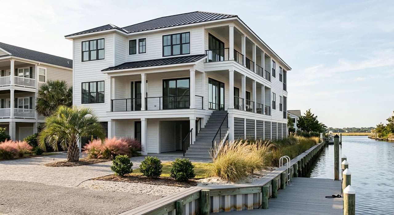
Canal-front neighborhoods are built around boating
Canal-front property is one of the most distinctive parts of Ocean Isle Beach Island. If your vision of coastal living includes boating, fishing, dock access, and a home that feels tied to the water in a different way than the beach strand, this area deserves a close look.
The town says many owners have canal-front property and identifies two canal types on the island: natural canals with vertical wooden bulkheads and concrete-canal areas with sloped concrete walls. The town also notes that boating and fishing are among the most popular activities for canal property owners.
That makes canal neighborhoods a very different lifestyle choice from oceanfront or second row. Instead of focusing on direct beach access, many buyers here are drawn to water access from the property itself and the day-to-day function of docks, bulkheads, and boat use.
Canal living comes with maintenance considerations
Canal-front living is not just about the view or boat access. It also comes with a different set of ownership considerations.
The town says special tax-district fees support maintenance dredging for both the concrete and natural canal systems, and it notes that natural-canals dredging is scheduled for fiscal year 2026-27. The town also states that bulkhead repair and construction require permits and must meet town standards.
For buyers, that means canal property should be viewed through both a lifestyle lens and a due-diligence lens. The canal type, bulkhead condition, and dredging context can all shape the ownership experience.
West End and Jinks Creek feel more marsh-and-waterway oriented
West End and Jinks Creek are worth separating from the rest of the island because they have their own character. This is not simply a generic extension of canal living.
The town has a dedicated Jinks Creek dredging page with parcel maps, public-hearing materials, and canal-tax-district resolutions. That level of separate documentation signals an area with its own engineering and policy context.
For many buyers, West End and Jinks Creek feel more marshy, boat-oriented, and waterway-centric than the beach strand. If your goal is a setting shaped more by canals, creek systems, and water access than by beach walkovers, this part of the island may stand out.
Typical streets and setting cues
Waterway-oriented buyers often focus on areas such as Waterway Drive SW, Market Place Boulevard, Seagull Way SW, Ocean Isle West Boulevard, and the broader West End and Jinks Creek setting. Based on the town’s canal descriptions and the island’s overall housing mix, these areas are often associated with single-family waterfront homes where docks, bulkheads, and boat access are major lifestyle features.
ICW frontage is different from canal-front
Intracoastal Waterway frontage deserves its own category because it is tied to the island’s broader waterway edge, not an interior canal system. That creates a different feel and a different risk profile.
The town’s flood-protection information says the ICW can rise during storms and push water over bulkheads into yards, storage areas, and streets. From a practical standpoint, that makes ICW-side locations some of the most exposure-aware parts of the island.
This does not mean these homes are less appealing. It means your evaluation should include a clear look at site conditions, bulkheads, elevation, flood zone, and insurance questions.
Flood zone review matters in every island neighborhood
If there is one due-diligence step that applies across every Ocean Isle Beach Island setting, it is flood review. The town says Ocean Isle Beach participates in the National Flood Insurance Program, that flood insurance is available for eligible buildings, and that mandatory purchase requirements apply in Special Flood Hazard Areas.
The town identifies three major flood zones locally: X, AE, and VE. That matters because flood exposure can change block by block, not just by whether a property is on the beach.
A canal-front home, an ICW-front home, an east-end oceanfront home, and a second-row home can each present different questions. Before you get too far into the process, it is smart to compare:
- Flood zone designation
- Insurance requirements
- Bulkhead or shoreline condition
- Street and lot position
- Proximity to active shoreline or canal-management areas
How to choose the right island setting
The best neighborhood fit usually comes down to the lifestyle you want most. Ocean Isle Beach Island offers different versions of coastal living, and each one asks you to prioritize something a little differently.
If you want the most direct beach access and a true on-the-strand feel, oceanfront is the obvious choice. If you want easy beach access with a bit more separation, second row may feel like a better balance.
If boating and fishing shape your ideal day, canal-front or West End and Jinks Creek areas may make more sense. If you are drawn to broad waterway views and understand the added flood and storm considerations, ICW frontage can be a strong fit.
The key is to compare homes through the lens of everyday living, not just listing photos. On Ocean Isle Beach Island, a few blocks can change traffic patterns, parking realities, maintenance needs, and even the kind of coastal experience you have year-round.
If you want help sorting through those differences, working with a team that knows the island block by block can save time and reduce surprises. The Cheek Team - A Boutique Brokerage can help you compare Ocean Isle Beach neighborhoods with clear local insight and a calm, personalized approach.
FAQs
Which Ocean Isle Beach Island setting has the easiest beach access?
- Oceanfront offers the most direct beach access, especially along strand-oriented areas such as Beach Drive SW and the east-end blocks around E First through E Seventh streets.
Which Ocean Isle Beach Island area is best for boating?
- Canal-front neighborhoods, West End, Jinks Creek, and some ICW-side properties are the most boat-oriented settings on the island.
What makes East End Ocean Isle Beach different from West End?
- The East End is more closely tied to active shoreline-management and erosion response, while West End and Jinks Creek are more connected to marsh, canal, and dredging systems.
What should buyers know about Ocean Isle Beach second-row streets?
- Second-row and access-adjacent streets can offer strong walkability to the beach, but summer traffic, paid parking, and parking restrictions are important to review.
Why is flood zone review so important on Ocean Isle Beach Island?
- The town identifies multiple local flood zones, and exposure can vary by block, setting, and water frontage, which can affect insurance and ownership planning.
